 |
|
|
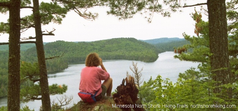
>>Special Note: To clarify the difference between roads and trails, the following roads are not hiking trails; The Sawbill Trail (County Road 2) is a two lane County Road from Hwy 61 in Tofte, Minnesota and north 25 miles to the shore of Sawbill Lake. The Caribou Trail (County Road 4) is a 17 mile two lane road from Hwy 61 just east of Lutsen, Minnesota to The Railroad Grade ( Forest Road 170.) The Gunflint Trail (County Road 12) is a two lane paved County Road from Grand Marais, Minnesota and travels 57 miles to Gull Lake. The Arrowhead Trail (County Road 16) is a two lane road from Hovland, Minnesota 16 miles to McFarland Lake. >>Watch out for ticks... we've been finding very small deer ticks on dogs and people. Hard to believe but, deer ticks are very active during the warm spring and fall days and often attach in the very private body areas. Deer ticks are a recent invasive species that has moved into North Shore areas, possibly from excessive deer populations. Superior Hiking Trail System – Moderate and difficult 200+ miles of hiking trails with various entry locations Access and parking at various locations along the hiking trail system. Most access points are where forest roads and county roads that cross the trail, and state parks the trail runs through. The Superior Hiking Trail, also known as the SHT, follows the shoreline of Lake Superior from Two Harbors, Minnesota to the Canadian border. Many spectacular vistas overlooking Lake Superior and the Sawtooth Ridges that run along the shoreline can be accesses by the SHT. Campsites are along the trail and are about 6-8 miles apart, are available on a first-come, first-served basis. Campsites have a tent site, latrine, fire ring and are located near water sources. You may also contact the Superior Hiking Trail Association at PO Box 4, Two Harbors, Minnesota 55616 You can give them a call at: 218-834-2700. North Shore Hiking Trails are Sponsored by the following lodging establishments
Caribou Falls Hiking Trail - Moderate 1.5 mile hiking trail Access and parking is the Caribou State Wayside rest area off Hwy 61, 8 miles south of Schroeder, Minnesota. Walking trail follows along the Caribou River and leads to Caribou Falls. You can continue onto the Superior Hiking Trail or return to the parking area. Schroeder; Lodging Dining Shopping Tofte; Lodging Dining Shopping or Lutsen; Lodging Dining Shopping You may also contact the Superior Hiking Trail Association at PO Box 4, Two Harbors, Minnesota 55616 You can give them a call at: 218-834-2700. Sugarloaf Interpretive Hiking Trail - Easy 1.5 mile hiking trail Access and parking is off of Hwy 61, 6 miles south of Schroeder, Minnesota. Trail runs through the forest and along the ledge rock to Sugarloaf Beach. Trail guide pamphlet is available at parking area. Schroeder; Lodging Dining Shopping Tofte; Lodging Dining Shopping or Lutsen; Lodging Dining Shopping Cross River Hiking Trail - Moderate 0.5 mile hiking trail Access and parking is the Cross River wayside rest off of Hwy 61 in Schroeder, Minnesota. From the wayside rest area you’ll climb gradually along the Cross River, passing the river’s gorges, stopping to appreciate the great views of the gorges is the whole purpose of this trail. You can continue up the river or return on the hiking trail to Hwy 61. Schroeder; Lodging Dining Shopping Tofte; Lodging Dining Shopping or Lutsen; Lodging Dining Shopping Temperance River Hiking Trail – Moderate 6 mile hiking trail system Access and parking is available in the Temperance River State Park off of Hwy 61 in Schroeder, Minnesota. Trails are on both sides of Temperance River, there are at least eight pools and seven overlooks along the sheer rocky ledges. Please use caution and keep children in hand and pets on leaches. Hiking Trail and campground maps are available at the Temperance River State Park. Overnight camping is available at Temperance River State Park campgrounds. Maps of the hiking trail and the State Park can be downloaded at www.northshorestateparks.com Schroeder; Lodging Dining Shopping Tofte; Lodging Dining Shopping or Lutsen; Lodging Dining Shopping Carlton Peak Hiking Trail – Easy to Moderate 5 mile hiking trail Access and parking is available off of the Sawbill Trail(county road # 2, a 2-two lane paved road) in Tofte, Minnesota. Go north on the Sawbill Trail from Hwy 61 in Tofte and drive two miles to the parking area on the east side of the road. Two round trip hiking destinations exist. You can take a shorter 3.5 mile hike to Carlton Peak or a 5 mile hike to the overlook can be experienced. Schroeder; Lodging Dining Shopping Tofte; Lodging Dining Shopping or Lutsen; Lodging Dining Shopping Britton Peak Hiking Trail – Difficult but short 0.3 mile hiking trail Access and parking is on the east side of the Sawbill Trail(county road #2, a 2-two lane paved road) in Tofte, Minnesota. A very short hike, that offers you a great view of Lake Superior. Steep cliffs near the top, please use caution and keep children in hand and pets on leaches. Schroeder; Lodging Dining Shopping Tofte; Lodging Dining Shopping or Lutsen; Lodging Dining Shopping Ray Berglund Wayside Rest Hiking Trail – Moderate 0.5 mile hiking trail Access and parking is in the Ray Berglund Wayside Rest off of Hwy 61 in Tofte, Minnesota, on the inland side of Hwy 61. This hiking trail follows the Onion River, very scenic. Schroeder; Lodging Dining Shopping Tofte; Lodging Dining Shopping or Lutsen; Lodging Dining Shopping Oberg and Leveaux Mountain National Hiking Trails – Moderate hiking The Oberg hiking trail is 2.2 miles and Leveaux hiking trail is 3.4 miles Access and parking for both trails is off of the Forest Road #336, which is off of Hwy 61 between the towns of Tofte and Lutsen, Minnesota on the inland side of Hwy 61. Fabulous high overlooks along the Oberg hiking trail give way to great views of Lake Superior, Moose Mountain and Oberg Lake. Very steep cliffs at the top, please use caution and keep children in hand and pets on leaches. The Leveaux Hiking Trail follows the ridge about 1000 feet above Lake Superior. Two of the best fall color hiking trails, fall colors peak late September until approximately mid October. Schroeder; Lodging Dining Shopping Tofte; Lodging Dining Shopping or Lutsen; Lodging Dining Shopping White Sky Rock Hiking Trail – Moderate 1 mile hiking trail Access and parking is off of the Caribou Trail (County Road # 4, a two lane paved road) in Lutsen, Minnesota. After a steep hike, you’re rewarded with a panoramic view of Caribou Lake. Great fall colors hiking trail. Schroeder; Lodging Dining Shopping Tofte; Lodging Dining Shopping or Lutsen; Lodging Dining Shopping Cascade River Hiking Trails – Moderate and difficult hiking trails with various loops up to 18 miles Access and parking is in the Cascade River State Park along Hwy 61 immediate next to the Cascade River bridge. Hiking trails are along both side of the Cascade River, with views of river gorges and waterfalls. Many other spur trails travel the rugged terrain along Lake Superior. There is also a trail to Lookout Mountain. Hiking Trail and campground maps are available at the Cascade River State Park. Overnight camping is available at Cascade River State Park campgrounds. Maps of the hiking trail and the State Park can be downloaded at www.northshorestateparks.com Schroeder; Lodging Dining Shopping Tofte; Lodging Dining Shopping or Lutsen; Lodging Dining Shopping Eagle Mountain Hiking Trail – Moderate to difficult 7 mile hiking trail Access and parking is off of Forest Road 170 near Two Island Lake. The highest and lowest areas in Minnesota are in Cook County. Eagle Mountain is the highest point in Minnesota at 2301 ft above sea level. Lake Superior is the lowest point at 601 ft above sea level. The Eagle Mountain Hiking Trail is rather rocky, with views of lakes, creeks, and small cliffs. About two thirds of the trail is in the BWCA (Boundary Waters Canoe Area) and self issued day permits must be in procession of parties hiking. Permits are available at trailhead and entry point #79 serves this trail. Overnight camping permits are required for the two campsites found on Whale Lake and at the base of the mountain, and are also available at the trailhead. Permit info can be found at the Boundary Waters Canoe Area Web site at: www.canoecountry.com/permits. Grand Marais; Lodging Dining Shopping or Gunflint Trail; Lodging Dining North Shore Hiking Trails are Sponsored by the following lodging establishments
Sweethearts Bluff Hiking Trail – Easy to difficult 1 mile hiking trail Access and parking is available in the Grand Marais Municipal Recreation Area. Trail starts at the west end of the RV Park. Trail passes picnic shelters and great views of the Grand Marais harbor and Lake Superior shoreline. Good place to walk dogs. Artists Point and Grand Marais Lighthouse – Easy 0.5 mile hiking trail Access and parking is available near the Grand Marais Coast Guard Station on Artists Point, at the only stop light in Grand Marais, drive towards the lake to the parking area. Trail explores the Lake Superior shoreline beneath the breakwall. Names of visitors can be seen dated as far back as 1892. Grand Marais; Lodging Dining Shopping or Gunflint Trail; Lodging Dining The following roads are not hiking trails; The Gunflint Trail (County Road 12) is a two lane paved County Road from Grand Marais, Minnesota and travels about 57 miles to Gull Lake. Pincushion Mountain Hiking Trails – Easy and Moderate hiking trails with various loops up to 15 miles Access and parking are at the Pincushion Overlook above Grand Marais. Go north on the Gunflint Trail (County Road 12) about 2 miles. Take a right-hand turn at County Road 53, and drive 100 yards. Try the loop to the Pincushion Mountain and see the Devil Track River gorge and great panoramic views of Lake Superior. You can connect to the Superior Hiking Trail from this trail. Grand Marais; Lodging Dining Shopping or Gunflint Trail; Lodging Dining Devil Track River Hiking Trails – Moderate hiking trails with various destinations up to 10 miles Access and parking is available at the Superior Hiking Trailhead about 1 mile from Hwy 61 on County Road 58 (Lindskoog Rd.) 4 miles east of Grand Marais. To the canyon; 1.5 miles, to the foot bridge; 2.5 miles and to Pincushion Mountains; 5 miles. Grand Marais; Lodging Dining Shopping or Gunflint Trail; Lodging Dining George Washington Memorial Pines Hiking Trail – Easy 3 mile hiking trail / Skijoring / Cross country skiing Access and parking is the George Washington Memorial Pines parking area, on the west side of the Gunflint Trail. From Grand Marais, go north on the Gunflint Trail (County Road 12) about 10 minutes and watch for the parking area and sign. This hiking trail is a abandoned road which runs through tall red pine stands to Elbow Lake. Trail does run through some wet areas, proper footwear a must. Ungroomed skijoring and cross country skiing trail in winter months. Grand Marais; Lodging Dining Shopping or Gunflint Trail; Lodging Dining Northern Light Lake Overlook Hiking Trail – Difficult and short 1 mile hiking trail Access and parking is available at the trailhead parking area up the Gunflint Trail (County Road 12) about 20 minutes north of Grand Marais. Watch for a small parking area on the east side of the road, after the Northern Light Lake Road (Forest Road # 140.) Hike about a half mile to get to the top of Blueberry Hill. This trail has great vistas overlooking Northern Light Lake. Grand Marais; Lodging Dining Shopping or Gunflint Trail; Lodging Dining Daniels Lake Hiking Trail – Easy 1.5 mile hiking trail Access and parking are available at the West Bearskin Lake boat Landing or the Clearwater Lake Boat Landing. This hiking trail requires a BWCA (Boundary Waters Canoe Area) Self issued day permit available at trailhead. Trail also provides access to the Border Route Hiking Trail system. Permit info and applications can be found at the Boundary Waters Canoe Area Web site at: www.canoecountry.com/permits. Grand Marais; Lodging Dining Shopping or Gunflint Trail; Lodging Dining Honeymoon Bluff Hiking Trail – Difficult and short 0.6 mile hiking trail Access and parking are available at the Honey Moon Bluff trailhead. Take the Gunflint Trail (County Road 12) to Clearwater Road / County Road 66 about one half hour up the Gunflint Trail (County Road 12) from Grand Marais. Drive 1 mile on CR 66 to the Honey Moon Bluff trailhead on the left side. A short and steep start to this hiking trail is a set of wooden stairs, which levels out about halfway to the bluff. Fabulous views of Hungry Jack Lake anytime of year, but fall is incredible! Grand Marais; Lodging Dining Shopping or Gunflint Trail; Lodging Dining Caribou Rock Hiking Trail – Moderate to difficult 7 mile hiking trail Access and parking is available at the trailhead off of the Hungry Jack Lake Road (County Road 65) about a half an hour up the Gunflint Trail (County Road 12) from Grand Marais. This hiking trail requires a BWCA (Boundary Waters Canoe Area) Self issued day permit available at trailhead. The first ľ of a mile is a well traveled path to the overlook of West Bearskin Lake. About a half mile further you’ll reach another overlook above Moss Lake. You can continue to the Stairway Portage and Rose Lake. Grand Marais; Lodging Dining Shopping or Gunflint Trail; Lodging Dining South Lake Hiking Trail – Moderate 7 mile hiking trail Access and parking is available at the trailhead off of the Gunflint Trail (County Road 12) across from Rockwood Lodge and Canoe Outfitters on the east side of the road. Watch for the trailhead shortly after you reach the 40mph zone. This hiking trail requires a BWCA (Boundary Waters Canoe Area) Self issued day permit available at trailhead. If you plan to camp overnight at the Partridge Lake campsite you must have a BWCA (Boundary Waters Canoe Area) entry and camping permit #59. This trail spans from Poplar Lake to the international border lake, South Lake. Trail passes the shores of Partridge Lake, and the campsite located there. Hikers will pass through old growth red and white pines on this hiking trail. Permit info can be found at the Boundary Waters Canoe Area Web site at: www.canoecountry.com/permits. Grand Marais; Lodging Dining Shopping or Gunflint Trail; Lodging Dining Topper Lake Trailhead and Mucker Lake Hiking Trails – Easy 1.5 to 6 mile hiking trails Access and parking is available at the trailhead at the end of Forest Road 317 about 35 minutes up the Gunflint Trail (County Road 12.) This hiking trail requires a BWCA (Boundary Waters Canoe Area) Self issued day permit available at trailhead. These easy hiking trails offer the hiker distance options of a hike 1.5 miles long or a longer hike to Mucker Lake of 6 miles and the option to continue hiking with a connection to the Border Route Hiking Trail which intersects at South Lake. Permit info can be found at the Boundary Waters Canoe Area Web site at: www.canoecountry.com/permits. Grand Marais; Lodging Dining Shopping or Gunflint Trail; Lodging Dining Crab Lake Hiking Trail – Easy 8 mile hiking trail Access and parking is available at the trailhead which begins at Loon Lake Lodge. About 40 minutes up the Gunflint Trail (County Road 12.) Turn onto Forest Road1416 and follow it to the side road just past the lodge. This hiking trail requires a BWCA (Boundary Waters Canoe Area) Self issued day permit available at trailhead. Trail also offers a connection with the Border Route Hiking Trail system. Grand Marais; Lodging Dining Shopping or Gunflint Trail; Lodging Dining Gunflint Lake Hiking Trails – Moderate and difficult trail system with various loops up to 26 miles Access and parking is available at the Loon Lake Landing off of the Gunflint Trail (County Road 12) about 40 minutes up the Gunflint Trail from Grand Marais. Take a turn onto Forest Road 1416 and park at the boat landing. Or you can also enter from any of the resorts or lodge on Gunflint Lake. Continue past FR 1416 five more minutes on the Gunflint Trail and turn onto South Gunflint Lake Road (County Road 50) and you can pick-up a hiking trail map at Gunflint Lodge or Gunflint Pines Resort and Campgrounds. The south side of Gunflint Lake offers spectacular views of Gunflint Lake and north over the Canadian border. A great destination for a hike, then lunch or dinner. Gunflint Lodge serves a full menu for lunch and dinner. Gunflint Pines serves convenience foods like burgers and pizza. Abundant wildlife can be seen while hiking, including moose, deer and birds of all types. For dining info call ahead; Gunflint Lodge 218-388-2294, Gunflint Pines 218-388-4454. Border Route Hiking Trail System – Moderate and difficult 70+ miles of hiking trails with various entry locations Access and parking is available from the Gunflint Trail (County Road 12) near Gunflint Lake about 45 minutes north of Grand Marais. Trail encompasses about 40 miles of hiking in the BWCA (Boundary Waters Canoe Area) and requires a Self issued day permit available at trailhead. If you plan to camp overnight at any campsite you must have overnight camping permit #83. Permit info can be found at the Boundary Waters Canoe Area Web site at: www.canoecountry.com/permits. The Border Route Hiking Trail runs from Gunflint Lake, along Rose Lake, Clearwater Lake, and then south between McFarland and John lakes. Eventually on to South Fowl, and south to Otter Lake and east to where the Otter Lake Road and the Swamp River intersect, on the east side of the Arrowhead Trail. From the Otter Lake Road the trail continues on to the east to the Grand Portage Indian Reservation, where it intersects with the Grand Portage Hiking Trail (next trail summary down), and then down to the shore of Lake Superior. Grand Marais; Lodging Dining Shopping or Gunflint Trail; Lodging Dining Magnetic Rock Hiking Trail – Easy 3 mile hiking trail Access and parking is available at a small trailhead and parking area about five minutes north on the Gunflint Trail (County Road 12) of County Road 50, and is on the east side of road. About 50 minutes up the Gunflint Trail (County Road 12) from Grand Marais. This hiking trail requires a BWCA (Boundary Waters Canoe Area) Self issued day permit available at trailhead. Look for Forest Road 144 and the Magnetic Rock Trail sign. Trail goes to a large 60 foot tall spear shaped rock that makes compasses spin. Trail does continue onto the Gunflint Lake Hiking Trails. Please pick up a hiking trails map at any of the lodges or resorts on Gunflint Lake (detailed in the above description of the Gunflint Lake Hiking Trails.) Permit info can be found at the Boundary Waters Canoe Area Web site at: www.canoecountry.com/permits. Grand Marais; Lodging Dining Shopping or Gunflint Trail; Lodging Dining Kekekabic Hiking Trail – Moderate to difficult 38 mile hiking trail Access and parking is available at both trailheads, the east trailhead is on the west side of the Gunflint Trail (County Road 12) 46 miles north of Grand Marais, Minnesota. The west trailhead is located in Ely, Minnesota. The "Kek" Trail is a historic 1930s trail for firefighters to reach and man fire towers during the spring to fall fire season. After being discarded from maintenance by the U.S. Forest Service in the 1980s, a small backpacking club resurrected the trail for all of us to enjoy. The Kek, is true wilderness hiking trail, much of the trail winds its way through the Boundary Waters Canoe Area, BWCA for short. A Self issued day permit is required for day hiking and is available at trailhead. If you plan to camp overnight at any campsite you must have an overnight camping permit for entry point #56. Permit info can be found at the Boundary Waters Canoe Area Web site at: www.canoecountry.com/permits. Grand Marais; Lodging Dining Shopping or Gunflint Trail; Lodging Dining
The following roads are not hiking trails; The Arrowhead Trail (County Road 16) is a two lane road from Hovland, Minnesota 17 miles to McFarland Lake. Kadunce River Hiking Trail – Easy 1.5+ mile hiking trail Access and parking is available at the Kadunce River wayside rest area nine miles east [ up the shore ] of Grand Marais on Hwy 61. Trail follows the Kadunce River and intersects with the Superior Hiking Trail about one mile from Hwy 61. A nice cobblestone beach, picnic tables, historic plaque and ample parking are available at the rest area. Grand Marais; Lodging Dining Shopping or Gunflint Trail; Lodging Dining Superior Hiking Trail System – Moderate and difficult 200+ miles of hiking trails with various entry locations Access and parking at various locations along the hiking trail system. Most access points are where forest roads and county roads that cross the trail, and state parks the trail runs through. The Superior Hiking Trail, also known as the SHT, follows the shoreline of Lake Superior from Two Harbors, Minnesota to the Canadian border. Many spectacular vistas overlooking Lake Superior and the Sawtooth Ridges that run along the shoreline can be accesses by the SHT. Campsites are along the trail and are about 6-8 miles apart, are available on a first-come, first-served basis. Campsites have a tent site, latrine, fire ring and are located near water sources. Grand Marais; Lodging Dining Shopping or Gunflint Trail; Lodging Dining You may also contact the Superior Hiking Trail Association at PO Box 4, Two Harbors, Minnesota 55616 You can give them a call at: 218-834-2700. Devil’s Kettle Hiking Trail – Moderate 7 miles of hiking trails Access and parking is available at the Judge C.R. Magney State Park 14 miles east of Grand Marais. Hiking trail follows the Brule River with incredible views of waterfalls, The Devil’s Kettle is a must see, a bottomless hole in the basalt bedrock that a 50 foot waterfall disappears into. The hike to and back from the Devil’s Kettle is 2.25 miles long and the entire hiking trail system is 9 miles. You can also access the Superior Hiking Trail from this hiking trail. Maps of the hiking trail and the State Park can be downloaded at www.northshorestateparks.com Grand Marais; Lodging Dining Shopping or Grand Portage; Lodging You may also contact the Superior Hiking Trail Association at PO Box 4, Two Harbors, Minnesota 55616 You can give them a call at: 218-834-2700. Grand Portage Hiking Trail – Moderate to difficult 16.5 mile hiking trail Access and parking is available at the Grand Portage National Monument about 36 miles east of Grand Marais off of Hwy 61. Follow the National Monument signs to the trailhead and parking area at the Monument. The Grand Portage Hiking Trail is a very historic trail, once used by Ojibwe Indians, trappers, voyageurs, explorers, and missionaries. Trail winds 630 feet above Lake Superior until it reaches the once busy Fort Charlotte on the banks of the International Pigeon River. A brochure is available at the A Great Hall at the monument. Grand Marais; Lodging Dining Shopping or Grand Portage; Lodging Mount Rose Hiking Trail – Difficult and short 1 mile hiking trail Access and parking is available at the Grand Portage National Monument about 36 miles east of Grand Marais off of Hwy 61. Follow the National Monument signs to the trailhead and parking area at the Monument. Self guided brochures are available at the monument. You’ll climb 300 feet along a paved pathway with many nice overlooks of the bay and fur trade headquarters. Grand Marais; Lodging Dining Shopping Hiking or Grand Portage; Lodging Partridge Falls Hiking Trail – Easy 10 mile hiking trail Access and parking is available on the Partridge Falls Road. Take Hwy 61 east to the Mineral Center Road (County Road 72) and turn north on Partridge Falls Road. Five mile hike along the Partridge River until you reach a 40 foot waterfall. Grand Marais; Lodging Dining Shopping or Grand Portage; Lodging Hiking Grand Portage State Park Hiking Trails – Easy 3.5 mile hiking trail and accessibility for disabled persons Access and parking is available at the Grand Portage State Park about 37 miles east of Grand Marais (5 miles east of Grand Portage) on Hwy 61. From the State Park office the High Falls Hiking Trail begins its half mile path along the international Pigeon River to the 120 foot waterfall. The Middle Falls Hiking Trail also begins at the State Park office, and winds its way through ridge tops, boreal forest terrain and along the Pigeon River to views of the river gorge and the Big Lake Superior. Maps of the hiking trail and the State Park can be downloaded at www.northshorestateparks.com Grand Marais; Lodging Dining Shopping or Grand Portage; Lodging Mount Josephine Hiking Trail – Difficult 1.3 mile hiking trail Access and parking is available at the Grand Portage Village and County Road 17, about 37 miles east of Grand Marais (5 miles east of Grand Portage) on Hwy 61. From the parking area next to CR 17 walk a Ľ mile to the trailhead. A steep switchback will take about 25 minutes to climb 800 feet. What you will find at the top is well worth the effort. Phenomenal panoramic views will amaze you at the top of Isle Royale, Lake Superior, Pigeon Point and the Susie Islands. Grand Marais; Lodging Dining Shopping or Grand Portage; Lodging Hiking Trails in the BWCA are available at www.bwcaw.com/hike
|
|
Request Advertising Info Media and Public Relations | Privacy Policy All Original Content and Coding
Copyright Updated Jan 22, 2020 |
More Area Web sites |